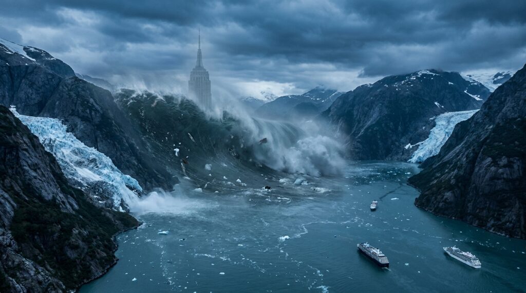
A Wall of Water Taller Than the Empire State Building
In the early hours of August 10, 2025, a remote Alaskan fjord became the stage for one of the most extraordinary geological events ever recorded. A colossal section of mountain collapsed into Tracy Arm Fjord in southeastern Alaska, unleashing a megatsunami that reached an astonishing 481 meters in height. That is taller than the Empire State Building, taller than the Eiffel Tower, and second only to the infamous 1958 Lituya Bay megatsunami in the history of modern measurements. (Reuters)
The event occurred in a narrow glacial fjord surrounded by steep granite cliffs, waterfalls, and retreating ice fields inside Alaska’s Tongass National Forest. Scientists say the tsunami was triggered when tens of millions of cubic meters of rock detached from a destabilized mountain slope and crashed into the water below. The force of the impact displaced an enormous volume of seawater almost instantly, generating a vertical surge unlike conventional ocean tsunamis caused by earthquakes. (Reuters)
Researchers later described the event as a climate-driven geological disaster, warning that warming temperatures and retreating glaciers are increasing the likelihood of similar catastrophes across polar and subpolar regions. (The Guardian)
The Mountain That Lost Its Support
For centuries, glaciers in Alaska have acted like natural structural supports for the mountains around them. Massive bodies of ice pressed against unstable rock slopes, helping hold them in place. But as global temperatures continue to rise, those glaciers are retreating rapidly.
In Tracy Arm Fjord, the South Sawyer Glacier had been shrinking for years. According to scientists involved in the investigation, the glacier’s retreat removed critical support from the mountain wall above it. Without that icy buttress, the slope became increasingly unstable until gravity finally won. (Reuters)
The collapse was enormous. Researchers estimate that roughly 64 million cubic meters of rock plunged into the fjord in about a minute. The energy released was equivalent to a significant earthquake, generating seismic signals detected around the world. (Reuters)
What followed was almost unimaginable.
Water exploded upward through the narrow fjord, racing along steep rock walls and stripping vegetation from mountainsides hundreds of meters above sea level. The wave carved scars into the landscape that remained visible in satellite images long after the water settled. (Reuters)
Unlike ocean-wide tsunamis generated by tectonic activity, this megatsunami was highly localized. Its destructive power was concentrated inside the confined geography of the fjord, where steep walls amplified the energy instead of dispersing it.
A Disaster That Narrowly Missed Tourists
The timing of the event may have prevented a major human tragedy.
Tracy Arm Fjord is a popular destination for cruise ships traveling through Alaska’s Inside Passage. During the tourist season, vessels carrying thousands of passengers frequently navigate the fjord to provide close views of glaciers and wildlife. Some reports estimate that multiple cruise ships visit the region daily during peak periods. (El-Balad.com)
Fortunately, the landslide occurred around 5:30 a.m., before tourist traffic had entered the area. Scientists later described the timing as “unbelievably lucky,” warning that a similar collapse during regular cruise activity could have resulted in catastrophic loss of life. (South China Morning Post)
Following the event, several cruise companies reportedly altered routes or canceled visits to the fjord due to concerns about slope instability and future landslides. (The Times)
The incident raised difficult questions for Alaska’s booming tourism industry. Cruise tourism in the state has expanded dramatically over the past decade, bringing millions of visitors annually into remote glacial environments that are increasingly vulnerable to climate-related geological instability. (The Guardian)
Experts now warn that regions once considered safe scenic destinations may face escalating risks as warming accelerates glacial retreat.
Scientists Reconstructed the Event Without Video
Remarkably, there is no direct footage of the megatsunami itself.
The remote location and early-morning timing meant that no cameras captured the towering wave as it surged through Tracy Arm Fjord. Instead, scientists reconstructed the disaster using a combination of satellite imagery, aerial photography, seismic monitoring, terrain analysis, and computer modeling. (Reuters)
Investigators analyzed before-and-after images of the landscape, identifying massive areas where vegetation had been stripped away by the wave’s force. Seismic sensors recorded the landslide and the unusual movement of water inside the fjord. Researchers also identified evidence of a “seiche,” a phenomenon in which water oscillates back and forth within an enclosed basin for extended periods. In this case, the fjord reportedly continued sloshing for more than a day after the initial impact. (The Guardian)
The event generated seismic signals strong enough to resemble a magnitude 5.4 earthquake. Some of those vibrations traveled globally, providing additional clues about the magnitude of the collapse. (The Guardian)
This forensic reconstruction allowed scientists to estimate the tsunami’s peak run-up height at approximately 1,578 feet, or 481 meters. (Reuters)
Why Megatsunamis Are Different From Regular Tsunamis
The word “tsunami” usually brings to mind giant ocean waves triggered by undersea earthquakes. But megatsunamis are fundamentally different.
Traditional tsunamis often travel across entire ocean basins with relatively low wave heights in deep water before growing taller near coastlines. Megatsunamis, by contrast, are typically caused by massive landslides, volcanic collapses, or asteroid impacts that suddenly displace huge volumes of water in confined environments.
Because the energy is concentrated rather than spread across the open ocean, the resulting waves can become unimaginably tall. Fjords, narrow bays, and steep-walled lakes are especially vulnerable because their geography amplifies wave energy.
The 1958 Lituya Bay event in Alaska remains the most famous example. In that disaster, a massive rockslide triggered a wave reaching approximately 524 meters high, the tallest ever recorded. (CPG Click Petróleo y Gas)
The Tracy Arm event now ranks as the second-highest known tsunami in recorded history. (Reuters)
Scientists believe climate change may be increasing the frequency of such events in glacier-dominated regions worldwide.
Climate Change Is Reshaping Mountain Stability
The Alaska megatsunami is increasingly viewed not as an isolated freak event, but as part of a larger pattern linked to rapid environmental change.
Across the Arctic and sub-Arctic, glaciers are retreating at unprecedented rates. Permafrost is thawing. Rock previously locked in frozen conditions for thousands of years is becoming unstable. Mountain slopes that depended on ice for structural support are beginning to fail. (The Guardian)
Researchers studying climate impacts have warned for years that warming temperatures could increase the risk of landslides, glacier collapses, and cascading geological hazards in high-latitude regions. (arXiv)
The Tracy Arm disaster may represent one of the clearest real-world examples of those warnings becoming reality.
Scientists involved in the study emphasized that glacier retreat was not merely a background factor. They argued it was directly responsible for destabilizing the mountain slope that collapsed into the fjord. (Reuters)
That conclusion has transformed the megatsunami into a powerful symbol of how climate change can trigger sudden and violent secondary disasters beyond rising temperatures and sea levels.
The Growing Threat to Coastal Communities
Although Tracy Arm Fjord itself is sparsely populated, experts fear similar events could threaten inhabited regions in the future.
Many communities worldwide are located near steep coastal terrain vulnerable to landslides. Norway, Greenland, Chile, Canada, and parts of New Zealand all contain fjords or glacial valleys where warming temperatures could destabilize mountain slopes.
In recent years, scientists have documented increasing concerns about “climate-sensitive slopes” in Arctic environments. Some regions are now being monitored continuously for signs of movement. (The Guardian)
One particularly alarming factor is the possibility of limited warning time.
Traditional tsunamis generated by earthquakes may provide hours of notice for distant coastlines. Landslide-generated megatsunamis can form within seconds or minutes, leaving little opportunity for evacuation.
The Alaska event demonstrated just how rapidly such disasters can unfold. The mountain collapsed, the wave formed, and the fjord was transformed almost instantly.
Researchers are now exploring whether seismic anomalies detected before the collapse could eventually support early warning systems. (Reuters)
Cruise Tourism Faces a New Reality
The megatsunami has also sparked renewed scrutiny of cruise tourism in environmentally fragile Arctic regions.
Alaska’s cruise industry has experienced explosive growth over the past decade. Massive ships routinely travel close to glaciers and steep fjord walls to provide passengers with dramatic views of ice fields, wildlife, and remote wilderness landscapes.
But climate change is altering those same landscapes in unpredictable ways.
The Tracy Arm incident demonstrated that some of the world’s most visually stunning destinations may also carry hidden geological dangers. (The Guardian)
Industry analysts say cruise operators may need to adopt more sophisticated risk assessments, including real-time geological monitoring and revised navigation protocols for unstable fjords.
Insurance implications could also become significant. If climate-driven geological hazards increase in frequency, insurers may demand stricter safety standards or higher premiums for routes through vulnerable regions.
For local economies dependent on tourism, the stakes are enormous.
A Planet Entering an Era of Compound Disasters
The Alaska megatsunami reflects a broader trend scientists increasingly describe as “compound climate risk.”
Climate change does not simply raise temperatures. It interacts with geological, hydrological, and ecological systems in ways that can produce cascading disasters.
Melting glaciers destabilize mountains. Thawing permafrost weakens infrastructure. Rising seas amplify storm surges. Drought increases wildfire intensity. Extreme rainfall triggers landslides.
In many cases, the most dangerous consequences emerge not from a single event, but from chains of interconnected failures.
The Tracy Arm collapse illustrates this dynamic perfectly. Warming temperatures contributed to glacier retreat. Glacier retreat destabilized the mountain. The mountain collapse generated the megatsunami. The tsunami threatened tourism infrastructure and human safety.
Each stage amplified the next.
Researchers argue that understanding these interconnected risks will become increasingly important as climate systems continue changing. (arXiv)
Could It Happen Again?
Scientists say yes.
In fact, some experts believe similar events are inevitable as glaciers continue retreating across the Arctic.
The steep topography of Alaska’s fjords creates ideal conditions for landslide-generated megatsunamis. Thousands of unstable slopes exist throughout the region, many of them located above waterways frequented by tourists and fishing vessels.
Remote sensing technology has revealed growing instability in multiple glacial valleys, raising concerns about future collapses. (The Guardian)
Researchers emphasize that not every landslide will produce a giant tsunami. The geometry of the slope, the speed of collapse, the volume of rock, and the shape of the water body all influence wave formation.
But the underlying drivers of instability are intensifying.
The same warming trends linked to the Tracy Arm collapse are accelerating worldwide.
Lessons From the Edge of the Arctic
The 2025 Alaska megatsunami may ultimately become one of the defining climate-linked disasters of the decade.
Not because it caused mass casualties. Remarkably, it did not.
Its importance lies in what it revealed about the changing relationship between climate and geology.
For decades, climate change discussions focused primarily on heatwaves, sea-level rise, and storms. The Tracy Arm disaster demonstrated that warming can also destabilize entire landscapes, triggering sudden physical transformations with extraordinary destructive potential.
The event also highlighted humanity’s growing exposure to fragile environments increasingly shaped by climate instability.
Tourists traveled to Tracy Arm seeking pristine wilderness and glacier views. Instead, the fjord became a dramatic reminder that the Arctic is changing faster than many risk models anticipated.
Scientists now warn that similar events could become more common as glaciers continue retreating around the world. (The Guardian)
Whether governments, industries, and communities adapt quickly enough remains uncertain.
What is clear is that the towering wave that surged through an Alaskan fjord in 2025 was not merely an isolated geological curiosity.
It was a warning.il, cinematic composition, atmospheric depth, realistic lighting, epic environmental catastrophe, climate change theme